In my series of how to research Scottish family history, this month I am going to show you how mapping your ancestors using old maps can strengthen your family history research. Placing your Scottish ancestors on a map can help you understand their lives better and may break down those tricky brick walls.
Why use old maps?
The purpose of maps was to help people find their way. Although we continue to use maps on satnavs, they are essential to explore the past and to try and track down our ancestors. Old maps are a great resource in genealogy, from locating a specific street name to establishing the whereabouts of a farm or estate.
Maps are useful for working out how places mentioned in family stories fit together. A family tree with many generations is likely to contain a number of locations. So it is important to understand how these fit together. By understanding how a family tree works on a map can reveal stories of journeys which may otherwise have hidden away.
Different locations on a family tree may suggest a lot of movement. However when you study a map you may find these places are next to one another. Your ancestor may have remained in exactly the same place but the nearest church may be in the neighbouring parish. Alternatively, the residence may have been enumerated in the census under another parish.
If your ancestor moved from a village to a town, a map might show that it was the closest industrial area. Alternatively there may have been a direct road, canal, river or railway leading straight to it, making it the most obvious route to take.
Be aware that if you are not familiar with Scottish geography you may think that having a family from Thurso in 1851 may be the same one living in Stranraer in 1861. Consider the distance, would it have been possible for a family to travel 360 miles on foot or cart in the mid-1850s? It is not impossible but the distance should be considered carefully. So check the census returns for both families to make sure.
Try this exercise to map your ancestors
You can add an extra dimension to your family history research by discovering more about the area where your ancestor lived and worked. So try this little exercise:
- Take a branch of your family tree where several generations stayed in the same village or town for many years.
- Go to NLS maps website and find a map of the area for that time period.
- Locate and mark all the known locations of key events: births, marriages and deaths on the map.
This little exercise should start to give you a sense of the environment where your ancestors lived. Here are some tips to help further your research:
My 5 Top Tips
Use a modern map
The first task in your search is to locate the area where your ancestor lived. Use mapping websites such as a Google Maps or Bing Maps that offer a quick and easy way to locate a place. In addition, they allow you to check the proximity of two locations when you are searching for relative. Perhaps a son lived in a different village from his parents and you want to know how far he lived from them.
Understanding distances between families is useful to understand journeys by foot, horse, cart, canals or railways.
Look up an old map
Once you have located where your ancestors lived, old maps can help you discover more about the areas they lived in.
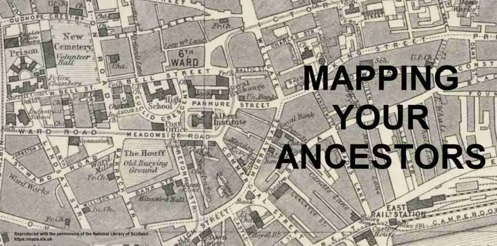
Unlike modern maps, old maps have interesting features, that have long since disappeared, including blacksmiths, coaching inns, water mills, farm names, estates, quarries, railway infrastructures, gas works, names for factories and industries, roads and benchmarks. They will mention jute factories in Dundee or an iron works in Kirkintilloch. The industry where your ancestor once worked during the 1800s no longer exists and you won’t find any record of them on modern maps. Therefore, the only source of gaining knowledge of where they worked and lived is to look at older maps.
Old maps can also identify the surrounding area and show changes in transportation that have developed or disappeared over the years. Transportation may include canals, railways, footpaths and roads.
Remember maps change over time. So if you’re researching the 1850s, then a 1930s map might not be so useful. If you can’t find the exact year, then try to get as close as possible.
Use NLS online maps for Scotland
I always use the National Library of Scotland (NLS) online maps to locate a Scottish settlement. It has one of the best collections of genealogy-friendly maps. Their interface also allows you to overlay historic maps onto modern day maps to help you make comparisons.
NLS online maps also have an option to view parish boundaries. This is particularly useful when trying to understand why an ancestor had children baptised in different parishes. They may have lived on the border of one parish but the closest church was in the next parish.
Old maps can also help with your house history research, so watch this space for a future blog on house history research.
Beware of name variations and name changes
Maps will contain different spellings of places, but they can also help decipher what was written in the census and the actual location.
Over time, place names have changed and evolved according to the inhabitants’ needs. For example, Perth was once known as St John’s Toun until the 17th century. The name is still used today for the local football team known as St Johnstone football club.
ScotlandsPlaces is a great resource to uncover the different spelling variations. If you put in a name into their search then variations of spellings will appear in their Ordnance Survey name books. For example, Leoch farm is also spelled as Liochs. So look up ScotlandsPlaces website first to see if there are any variations. Then search the different place names on the NLS maps website to get a more precise location.
So, approach all place names with caution and don’t presume that the street name still exists. For example, Swinton Row in Edinburgh from 1853 no longer exists because St James Centre and now St James Quarter have been built over it.
Maps, census returns and valuation rolls go hand-in-hand
Households appear in geographical order to show where the properties appear in the enumeration district. When you are searching for a family, also go to the front page of the census return to read the enumerator’s notes. These usually include a description of the walking route particularly in towns and burghs.
Valuation rolls are property ownership records created for the purposes of collecting local taxes. These were used to establish proof of ownership or tenancy of a property. They are also useful to identify the movements of ancestors between census returns. You can find them on ScotlandsPeople website and they start from 1855.
Census returns and valuation rolls sit naturally with maps, as they allow you to research the locations where your ancestor once lived.
To conclude:
Old maps are often overlooked by family historians. Actually, maps give us a picture of what the countryside, towns and villages looked like as far back as 300 years ago. They can show villages, towns, and cities as they were during the lifetime of our ancestors and can indicate the location of streets that have since been demolished or renamed.
Therefore, maps should be included as an important tool when searching for your ancestors. A detailed map can bring alive the area where your family lived, whether in a Scottish glen or a street in Glasgow.
If you have any questions about this blog, or if you would like to share your own ideas about how family history is important, then leave a comment below to start a discussion or or get in touch….
(Image ‘Reproduced with the permission of the National Library of Scotland’: Plan of Dundee to accompany directory 1885)
You may also like...
The Life of a Tollkeeper
A tollkeeper was a person who collected road fees from travellers. This old occupation was prominent during the 18th and 19th centuries.
Cameron Surname: Origin, Meaning & History
The Cameron surname has Gaelic origins and it is associated with Clan Cameron, one of the most influential Highland clans.
Ancestral Visit to Auchtermuchty, Fife
Auchtermuchty in Fife is known as Muchty to locals. What does Stratheden Whisky, Jimmy Shand and the Proclaimers have in common?